
The BBC has an interesting story on a European Space Agency project to take precise measurements of the Earth's gravitational field over the South Pole.
Map of City of Cleveland Land Annexations
Not counting the airport, most of the City of Cleveland was filled in by 1932:
It's That Time Again
The most-hated college football teams in each state, according to /cfb on Reddit:
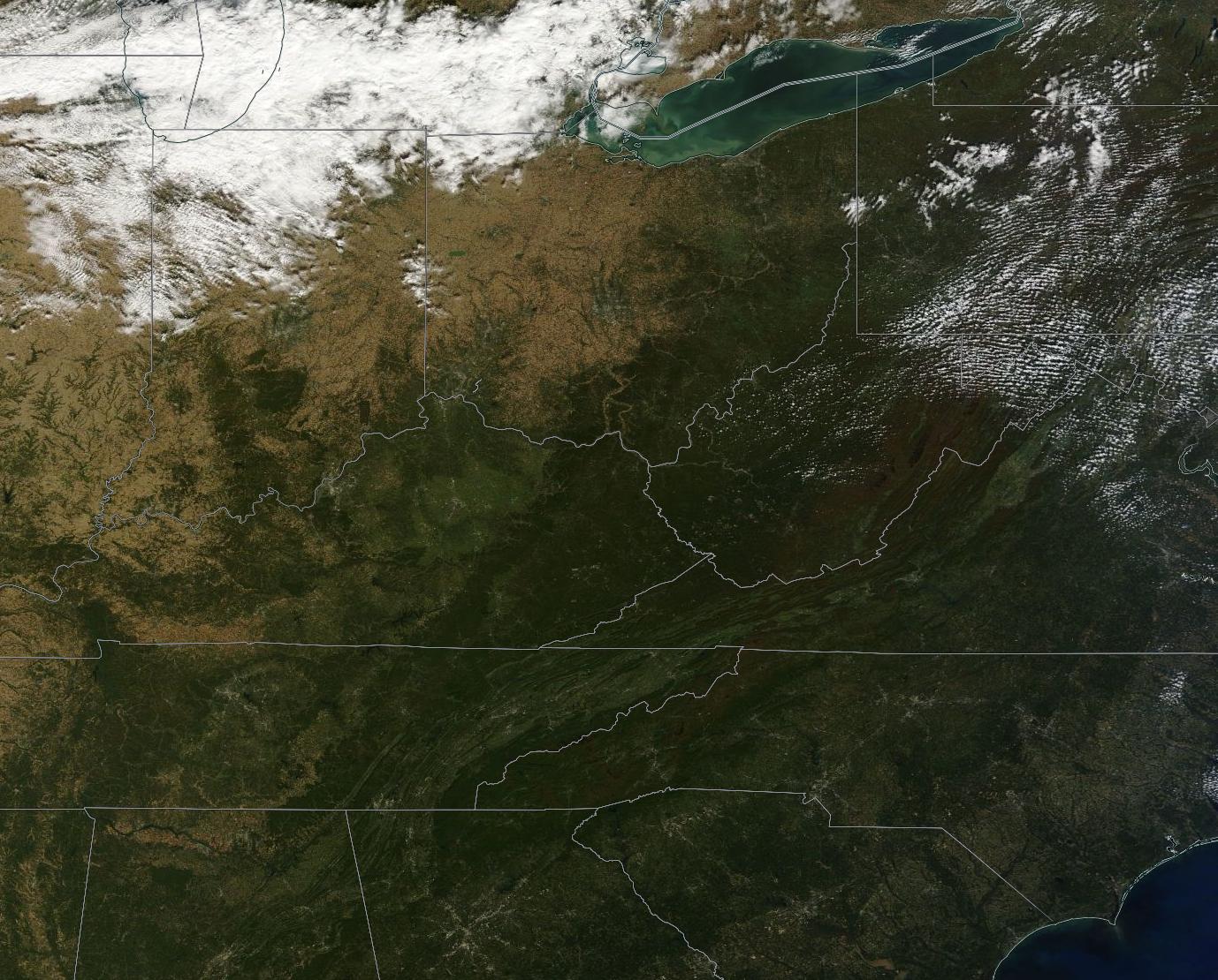
Fall Colors From Space
October 11 and 12 were clear days across most of the Great Lakes and Northeast, and the NASA Earth Observatory has highlighted some satellite imagery from those days showing the fall color change:
Fall Color Arrives in the U.S. and Canada
The images come from the MODIS instrument on board the Terra and Aqua satellites. Terra and Aqua are in sun-synchronous orbits and together they image every location on Earth at least once every two days.
MODIS captures over 36 spectral bands and has many scientific applications, but the reason I like MODIS imagery is that it provides a low-resolution, visible spectrum image of any location and updates very often. This means you can see what any particular spot on Earth would look like from orbit with your own eyes, every couple of days.
The NASA EOSDIS Worldview page lets you view Terra and Aqua MODIS imagery in very nearly real-time. It even lets you export geo-referenced imagery, like this one I saved of the Terra imagery from today:
NCAA Fan Map
This is an older map, but college football season is approaching and this map is a favorite of mine.
The New York Times used the volume of Facebook "likes" for each ZIP code to put together a map of college football fandom.
Ohio State fans, similar to Wisconsin and Arkansas, pretty much form a contiguous block in their respective state. Others are much more divided.
I was in in Fort Wayne, Indiana, recently, and was surprised to see a sports bar with Ohio State, Michigan State, and Indiana University flags flying out front. I would have expected to see Purdue or even maybe Michigan flags; and looking at the map, appears that Notre Dame fans make up the majority of the Fort Wayne area, followed by Purdue and then Ohio State, so I suspect that particular bar was a bit of a unique outlier.
Still, there are plenty of Michigan fans in Toledo, Ohio University and West Virginia fans in Southeast Ohio, and University of Cincinnati and University of Kentucky fans in the Cincinnati area.
As always, with an interactive map like this, the real fun is zooming in and looking closely at specific areas.
America's Sunniest and Least Sunniest
The Washington Post has an interesting interactive map of the most- and least-sunny counties in the United States:
Map: Where America’s sunniest and least-sunny places are
As for Ohio, much of Northeast Ohio, from Cuyahoga County all the way down to Monroe and Belmont Counties in the south, is among the least-sunny parts of the entire nation. I would imagine this is a combination of our northern location, along with cloud cover created by the Great Lakes.
In general Ohio gets a little more sunshine gradually as you go southwest towards Cincinnati - except for one area of interest: Erie, Huron, and Lorain Counties, which are the sunniest counties in Ohio, and in fact just slightly above the national average.
ALTA/ACSM Survey Name Change
A new set of ALTA/ACSM survey standards will be coming out in 2016, and according to the latest News & Views from the NSPS (National Society of Professional Surveyors), they will be getting a name change as well, and will now be called ALTA/NSPS surveys.
ALTA stands for the American Land Title Association, and ACSM stands for the American Congress on Surveying and Mapping, which were the two organizations that came together to first create the ALTA/ACSM survey standards in 1964.
The ACSM was absorbed into the NSPS in 2012, so the name has seemed a little out-of-place since. I'm sure it will probably take some adjustment to get used to the new name, although I think in general practice most people refer to them as "ALTA surveys" anyway.
Although the official standards won't be released until February 2016, it looks like there may be a few other interesting changes coming as well, notably:
- A reason must be given for writing an "as surveyed" description
- A zoning letter or report must be provided to the surveyor before zoning information can be addressed on the survey
- Table A Item 18, requiring a statement about whether a site appears to be used as a solid waste dump, sump or sanitary landfill will be removed
- Table A Item 19, requiring a determination of wetlands areas will be removed
- Table A Item 20(b), which requires setting monuments on corners of easements which benefit the subject property, will be removed
Links Page Updated!
... although by "updated," I really mean "has been made functional."
Go over to http://northcoastgeo.com/links/ or use the LINKS button on the navigation bar at the top of the screen to check out the new links page.
There you can find links to surveying professional organizations, mapping services, tools, and links to county engineer, auditor and recorder sites.
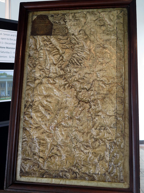
Summit County Relief Model
I was doing some plat research at the Summit County Courthouse this week, when I noticed this really interesting Summit County Relief Map on display
You really need to view the full image to fully appreciate it. It's a map of Summit County, but with actual relief instead of contours. The Cuyahoga River valley is obviously very prominent.
I'm not sure when it was made - I didn't see a date anywhere on the model, and I didn't see an explanatory sign anywhere. I would guess it's from sometime between 1880 and 1910. It was hard to get a really good photo because it's behind glass; it appears to be a temporary display by the Summit County Historical Society. I think I should make a trip over there sometime to see if I can get a better look at it!
Alongways
I came across a webpage/cell phone app the last week that I've found incredibly useful:
I'm sure most of us are familiar with using services like Google Maps to find the closest locations of particular types of things, whether you're looking for a particular restaurant, grocery store, gas station, etc.
And Google Maps is good at that - as long as you are looking for the closest example to where you are located at that moment.
But more often, I would much rather know what the most convenient locations are along a route that I need to travel. If I am driving from Akron to Fremont to Columbus to Akron, it may be more helpful to know where a post office is along that route, rather than which one is closest to my current location.
That's where Alongways comes in - you enter your beginning and ending points, and then search for a particular thing along that route. It will suggest the most convenient examples along that route (it will cast a slightly wider net over a longer route).
I've been really happy with the results so far. The webpage is free, and there is an app available for Android or iOS for $1: